
geoscience

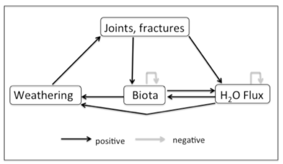
THE GEOMORPHOLOGICAL NICHE OF TREES

In a 2009 article I introduced the concept of a geomorphological niche, defined as the resources available to drive or support a particular geomorphic process (the concept has not caught on). The niche is defined in terms of a landscape evolution space (LES), given by

where H is height above a base level, rho is the density of the geological parent material, g is the gravity constant, and A is surface area. The k’s are factors representing the inputs of solar energy and precipitation, and Pgrepresents the geomorphically significant proportion of biological productivity (see this for the  background and justification).

HOW COMPLEX CAN IT BE?

Back in 2006, novelist and country music singer-songwriter Kinky Friedman ran (unsuccessfully) for governor of Texas. His campaign slogan, a rather pointed reference to the fact that recent occupants of the office George W. Bush and Rick Perry were not the sharpest tools in the shed, was "how hard could it be?" I can't answer that, but I can answer, after a fashion, the question of how complex or simple an Earth surface system can be.

POWER LINES & FLOODPLAINS

As mentioned in my most recent post, in examining some of the imagery from recent floods in Texas, even in non-urban areas human infrastructure such as roads, levees, railways, and impoundments can profoundly influence flooding patterns and channel-floodplain hydrological and sediment connectivity. In several cases I noted that power line rights-of-way were zones of concentrated flow on the floodplain, which reminded me that I have seen similar phenomena elsewhere.

I am aware of work on the role of power lines in landscape ecology—as habitats, corridors, and as a factor in habitat fragmentation. I do not recall ever seeing anything about their role as channels or catch-basins for floodwater. The rights-of-way are typically vegetated, but often short, second-growth shrubs and grasses rather than the adjacent forests and trees. They may also be compacted enough to show slightly lower elevations than adjacent bottomland forests. In any case, they can clearly have strong local influences in channel-floodplain connectivity.

CONNECTIVITY & FLOODPLAIN INFRASTRUCTURE

Like many other river scientists and managers in recent years, I have occupied myself quite a bit with considerations of hydrological and sediment connectivity in fluvial systems. In my case, channel-floodplain connectivity in alluvial rivers has been a particular concern.

In examining some of the imagery obtained during floods in Texas following Hurricane Harvey, I was reminded of something that I would not have disputed but have never really focused on either—the profound effect of human structures and modifications on floodplain hydrology and geomorphology. In urbanized areas this has long been pretty obvious, but even in rural areas the effects can be striking.

The images below all came from the U.S. National Geodetic Survey (https://storms.ngs.noaa.gov/storms/harvey/index.html#7/28.400/-96.690). The imagery was acquired by the NOAA Remote Sensing Division, with an approximate ground sample distance for each pixel of 0.5 m. Images were collected near the peak of flooding in many cases.

SELF-LIMITING ECOSYSTEM ENGINEERING IN NON-KARST REGOLITH

This is a follow-up to my previous post on emergent ecosystem engineering in epikarst, so I won't repeat much of the background or analytical details. There I argued that interactions among rock weathering, moisture flux, biological effects (particularly roots and their symbionts) and soil operate such that if weathering is moisture-limited, and biota are limited by water availability and below-ground space, the system is dynamically unstable. Positive feedbacks dominate so as to reinforce or accelerate dissolution, joint/fracture widening, root growth, and soil accumulation. The net effect is to develop the epikarst as increasingly hospitable habitat. This continues, according to the analysis, until weathering becomes reaction-limited and subsurface space and moisture are no longer significant limiting factors for plant growth. Under the latter circumstances the system is dynamically stable, implying resilience to relatively small changes or disturbances and slower change.

EMERGENT ECOSYSTEM ENGINEERING IN EPIKARST

Epikarst is defined as the uppermost zone of dissolution in karst, including whatever soil cover exists. The purpose of this analysis is to explore some of the interactions among geological controls, weathering, biota, moisture flux and soil accumulation in the regolith or critical zone of karst systems.

Epikarst exposed by gullying, Bowman's Bend, Kentucky

Figure 1 shows the interactions among geological controls (joints, fractures, bedding planes), weathering, subsurface biological activity, moisture flux, and soil accumulation the earlier stages of soil development in epikarst. The system is dominated by positive feedbacks because in early stages of epikarst development there is limited space for biological activity (e.g., roots), and moisture fluxes are limited by the size of joints, fractures, and incipient conduits. The other positive feedbacks reflect well established relationships among chemical weathering, enlargement of joints, etc., water availability, and organisms. I assume some external (to the system shown) limitations on biological activity and moisture flux.

ANTHROPIC FLUVIAL SEDIMENTATION

Geomorphology has just published a special issue on anthropic sedimentation in fluvial systems, in the centennial year following the publication of G.K. Gilbert's seminal Hydraulic Mining Debris in the Sierra Nevada. L. Allan James (AJ) edited the special issue, along with Scott Lecce and myself. Lots of good stuff in there, if I do say so myself. The issue includes an article coauthored by AJ, Scott and myself, titlled A centennial tribute to G.K. Gilbert's Hydraulic Mining Débris in the Sierra Nevada. The abstract is below, and you can download it here:

While Scott and I did enough work to deserve having our names on this, AJ really deserves most of the credit. He conceived the whole enterprise, recruited us to help, and was truly the lead author on the article above and the short introduction to the special volume. 

AGGRESSIVE PASSIVE RESTORATION

Years ago, in my days at East Carolina University, M.A. student Don Belk (now a planner with the N.C. Department of Commerce) and I worked on issues related to hydrological restoration of artificially drained wetlands in eastern North Carolina. Basically, we found that something closely approaching the pre-drainage hydrology could be achieved in most cases by simply not maintaining the drainage ditches and canals (see this, that, and the other). In this flat, wet topography and humid subtropical climate the anthropic channels quickly accumulate sediment, organic debris, and living vegetation, losing their conveyance capacity and essentially becoming linear detention ponds in a few years. Thus, except for some local water table drawdown during dry spells in the vicinity of the ditches and canals, and whatever peat may have oxidized when the artificial drainage was working, the hydrology can be passively restored. If you don't believe me, ask someone who farms artificially-drained land in the N.C. coastal plain--they'll tell you they have to clean out the ditches every two to five years.

BRAZOS RIVER FLOOD

As I write, the lower Brazos River west of Houston, Texas, has been in flood for more than seven days, and is likely to remain that way another week, minimum. The peak five days ago occur occurred at a gage height of 52.65 feet at the Rosharon gaging station (third highest ever, going back more than a century), and is still only about four inches below that, and not dropping appreciably. At the next gaging station upstream, at Richmond, TX, the stage was the highest on record. On August 31, near the peak at Rosharon and with water levels still above the designated major flood stage, U.S. Geological Survey personnel went to the site and measured the flow.

Location of the Brazos River Rosharon gaging site.

Subscribe to geoscience