
As I write, there is flooding in central Texas, and more to come. The focus is rivers and creeks in the San Antonio and Guadalupe River systems in the Balcones Escarpment area along the San Antonio-Austin Corridor, with effects beginning to felt downstream.
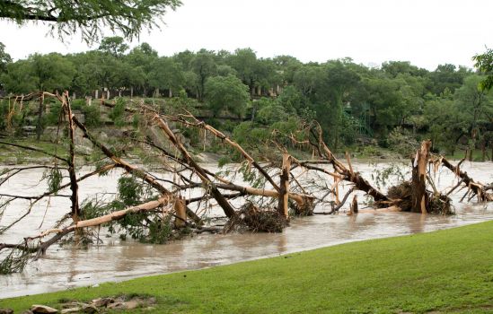
Destroyed trees along banks of the Blanco River, Wimberly, TX, after the flood of 24 May, 2015 (photo by Jay Janner, Associated Press).
This area is no stranger to large floods. In the vicinity of the Balcones escarpment, the Guadalupe and other rivers that cross the escarpment are prone to high-magnitude flooding—the incidence of such flooding is higher than any other area of the U.S. Caran and Baker (1986) identified a combination of climatological and runoff-response factors contributing to the high flooding potential. The region lies within a zone of convergence of polar air masses and easterly waves or tropical cyclones. A well-developed easterly wave approaching a lobe of high pressure, such as those often associated with a polar surge into middle latitudes, may produce strongly instability and heavy rains, as was the case, for example in the extreme floods that occurred on the Guadalupe River in 2002. Orographic effects associated with the escarpment topography can also enhance these rains (Caran and Baker, 1986). Nielsen-Gammon et al.’s (2005) climatological analysis shows that in general, exreme rainfall events in central Texas are associated with a northern deflection of the northeasterly trade winds into Texas, with deep southerly winds extending into the troposphere. This pumps abundant tropical moisture into the region with high potential for instability. Precipitation events producing more than 20 in (500 mm) of rain occur several times per decade in Texas (Earl & Dixon, 2005; Neilson-Gammon et al., 2005).
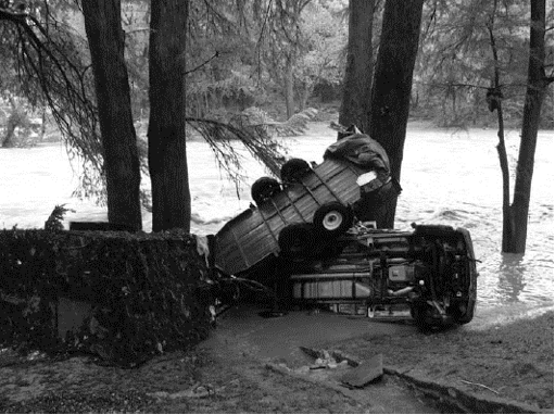
Cars transported by the Guadalupe River in Gruene, TX, during a June, 2010 flood (NWS photo).
The topography and surface conditions result in a large and rapid runoff response to heavy rainfall events. Steep slopes, narrow valleys, thin soils (many with low infiltration capacity) over limestone bedrock, and relatively sparse vegetation cover result in high runoff and consequent stream discharges. Several other studies have confirmed the atypical flood regime of this area, and the general causal factors identified above (Baker, 1977; Patton and Baker, 1977; Alfinowicz et al., 2005; Curran et al., 2005). Recent work suggests a general pattern of increasing base flow discharge in Hill Country rivers such as the upper Guadalupe as grasslands formerly degraded by overgrazing convert to woodlands (Wilcox and Huang, 2010). Unusually high roughness or flow resistance values in rivers of the Edwards Plateau and Balcones escarpment such as the upper Guadalupe may contribute to flooding by reducing channel conveyance capacity (Conyers and Fonstad, 2005).
The thin soils of the Edwards Plateau are believed to be a legacy of Quaternary climate change. A combination of temperature, precipitation, and vegetation changes led to soil degradation, according to the reconstruction of Toomey et al. (1993). During the late glacial maximum and the latter stages of the most recent glacial period (about 20-10 Ka), the uplands had thick, reddish, clay-rich soils under open savanna vegetation. The transition to the Holocene climate resulted in reduced vegetation cover, and initiated soil erosion and truncation. The general phenomena identified by Toomey et al. (1993) have been confirmed by other studies in the region (see review in Ricklis, 2004).
So what we have in this region is a confluence of factors (a perfect storm, if you will)—climatology, topography at both a broad (escarpment) and local scale (steep slopes), soils, vegetation, and land use—that combine to produce a propensity for high-magnitude floods. In this the San Antonio/Guadalupe River area is unique—there are certainly other areas particularly prone to flooding, but not for exactly the same reasons. But the area is also typical, in that all places and environmental systems have a unique combination of environmental factors and historical legacies (e.g., the Quaternary legacy of thin soils) that result in elements of uniqueness or idiosyncrasy, overprinted on the general laws and principles that apply to hydrology and flooding everywhere and always. Sometimes, from the human perspective, these “perfect landscapes” have obvious and negative aspects (e.g., extreme floods in Texas), sometimes obvious and positive traits (e.g., some famous wine-producing regions), but more often “perfection” that is more subtle.
-----------------------------------------------------------------------
Afinowicz, J.D., Munster, C.L., Wilcox, B.P. 2005. Modeling effects of brush management on the rangeland water budget: Edwards Plateau, Texas. Journal of the American Water Resources Association 41, 181-193.
Baker, V.R., 1977. Stream channel response to floods, with examples from Texas. Geological Society of America Bulletin 88, 1057-1071.
Caran, S.C., Baker, V.R., 1986. Flooding along the Balcones Escarpment, central Texas. In:The Balcones escarpment-geology, hydrology, ecology and social development in central Texas, Geological Society of America p. 1-14.
Conyers, M.M., Fonstad, M.A. 2005. The unusual channel resistance of the Texas Hill Country and its effect on flood flow predictions. Physical Geography 26, 379-395.
Curran, J.C., Bryan, D., Jennings, M. 2005. A comparison of modeled flood characteristics to measurements of the 2002 flood on the Guadalupe River, Texas. Physical Geography 26, 396-408.
Earl, R.A., Dixon, R.W. 2005. Reassessment of storm and flood probabilities in south-central Texas. Physical Geography 26, 365-378.
Nielsen-Gammon, J.W., Zhang, F., Odins, A.M., Myoung, B. 2005. Extreme rainfall in Texas: patterns and predictability. Physical Geography 26, 340-364.
Patton, P.C., Baker, V.G., 1977. Geomorphic response of central Texas stream channels to catastrophic rainfall and runoff. In: D.O. Doehring, Editor, Geomorphology In Arid Regions, State University of New York, Binghamton, NY, pp. 189–217.
Ricklis, R.A. 2004. The archaeology of the native American occupation of southeast Texas. In The Prehistory of Texas, Pertulla, T.K. (ed.). College Station: Texas A&M University Anthropology Series, No. 9; 181-197.
Toomey, R.S. III, Blum, M.D., Valastro, S., Jr. 1993. Late Quaternary climates and environments of the Edwards Plateau, Texas. Global and Planetary Change 7, 299-320.