
environment

BIOGEOMORPHIC EQUIVALENTS & FUNCTIONAL GROUPS

During some recent fieldwork doing forest biogeomorphology with colleagues in the Czech Republic, the idea of biogeomorphic equivalents came up. A biogeomorphic ecosystem engineer organism has a biogeomorphic equivalent if another species can potentially do the same biogeomorphic job. For example, bacteria that consume iron are important agents of weathering. There exist numerous species of iron-eating microbes, so if one is eliminated for whatever reason, another takes its place. Thus these Fe-processing bacteria have biogeomorphic equivalents.

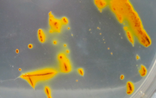
Acidophilous iron-oxidizing bacteria (USGS photo).

On the other hand, there exists no biogeomorphic equivalent for the stream-damming effects of beavers. The disappearance of Castor canadensis from a landscape means the loss of their biogeomorphic effects, as no other organism (save humans, of course), dams up streams.

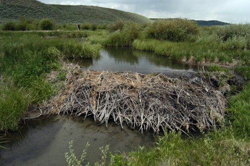
Wyoming beaver dam (photo: Wildlife Conservation Society).

RIVERS & TIPPING POINTS

Some have argued that in geomorphology and physical geography the term "tipping point" does not describe any concepts or phenomena not long recognized by the fields. The tipping point concept does not (it is argued) have any conceptual or analytical value added. I agree. Here is a previous post on tipping point metaphors.

Blanco River, Texas.

Notwithstanding that, tipping point terminology is au courantin both public discourse and science, particularly as it relates to global and broad scale environmental change. Thus--perhaps analogously to buzzwords such as "sustainability" and "resilience"-- if you want to be a part of broader scientific conversations, it pays to employ the trendy term.

RISING SEAS & COASTAL RESPONSES

As sea level rises--and it is rising!--it is causing geomorphological, hydrological, and ecological changes in coastal environments. Though "bathtub" models, which show where the shoreline would be with sea level increased by a certain amount, are useful in showing areas of potential impact, that's not how actual responses to sea level work. Not only does the ocean level change, but also the base level for rivers and terrestrial processes, salinity, ecological habitats, hydroperiods, and any number of other factors. 

Sand and mud flats along the eroding Neuse River estuary shoreline, NC. 

AGGRESSIVE PASSIVE RESTORATION

Years ago, in my days at East Carolina University, M.A. student Don Belk (now a planner with the N.C. Department of Commerce) and I worked on issues related to hydrological restoration of artificially drained wetlands in eastern North Carolina. Basically, we found that something closely approaching the pre-drainage hydrology could be achieved in most cases by simply not maintaining the drainage ditches and canals (see this, that, and the other). In this flat, wet topography and humid subtropical climate the anthropic channels quickly accumulate sediment, organic debris, and living vegetation, losing their conveyance capacity and essentially becoming linear detention ponds in a few years. Thus, except for some local water table drawdown during dry spells in the vicinity of the ditches and canals, and whatever peat may have oxidized when the artificial drainage was working, the hydrology can be passively restored. If you don't believe me, ask someone who farms artificially-drained land in the N.C. coastal plain--they'll tell you they have to clean out the ditches every two to five years.

THE NITROGEN BOMB

I just finished reading Paul Bogard's The Ground Beneath Us, (I recommend it), which among other things warns us yet again about the serious issues--environmental, economic, public health, food security--associated with over-reliance on chemical and fossil-fuel intensive industrial agriculture. It's a good 40-years-later follow-up to Wendell Berry's classic Unsettling of America: Culture and Agriculture (Sierra Club Books, 1977).

It also reminded me of a much more technical and difficult book I read a few years back, Jozef Visser's Down to Earth, subtitled "A Historical and Sociological Analysis of the Rise of 'Industrial' Agriculture and the Prospects for the Re-rooting of Agriculture in the Local Farmer and Ecology. Visser, who has graduate degrees in chemistry and a long career in agricultural chemistry, returned to graduate school later in life to produce this book, which is his dissertation from the University of Waginengen (Netherlands). A pdf is available free at the link above, and I recommend it.

MAKING PEACE WITH MACROPORES

The journal Hydrological Processes has recently been publishing a series of articles and commentaries in tribute to the estimable Keith Beven, the recently retired hydrologist from the University of Lancaster. One of his many fundamental contributions has consisted of drawing attention to the importance of, and making fundamental insight into, the phenomenon of macropores and preferential flows. One of those commentaries, by Markus Weiler, addressed these contributions as well as unresolved issues in understanding and simulating preferential flow.

No hillslope hydrologist, geomorphologist or pedologist would dispute the existence or frequent occurrence of preferential water flux in soils, or its importance in many cases at the scales of soil physics to hillslopes. However, Weiler points out that the observed differences in flow pathways at the pedon or hillslope scale are not necessarily detectable at the watershed scale. Does macropore flow matter at the catchment scale? Weiler's answer is yes, though he points out that many scientists believe otherwise.

PROVIDERS OF PREDICTABILITY

From my student days onward, the aspects of nature that interested me most were the apparent anomalies--the things that were uncertain and unpredicted; that weren't like they were supposed to be. Nature contains both regular, ordered, predictable aspects, and irregular, disordered and unpredictable facets. As scientists we are taught to focus on the former and eliminate, ignore, or circumvent the latter.  But anyone who spends much time in the field knows that our planet is a source of infinite variety and ever-increasing uncertainty (because the more you learn, the more you realize that you don't know). But what always fascinated me was not that (for instance) the soils or streams or eastern North Carolina or central Kentucky fit, and can be predicted by, some broad pattern. It was the fact that you can often auger the ground at two spots less than a meter apart and find completely different soils, or walk or canoe a stream channel and easily find features not explained or predicted by the conventional scientific wisdom.

THE BIG FLOOD

In 2011, a massive flood swept through the Lockyer Creek valley in southeast Queensland, Australia. The environmental, economic, and geomorphic impacts were immense, and Australian geoscientists immediately set out to document, understand, and contextualize them. The “Big Flood” project, led by Jacky Croke, has already produced 19 scientific journal articles, and they just this week went live with their web site, with numerous resources for scientists, managers, and the general public.

Floodwaters in Grantham, QLD, 2011 (http://www.thebigflood.com.au/whathappened.html)

The project has already produced some novel results with respect to flood geomorphology and hydrology, and is unique as far as I know with respect to direct efforts to integrate geoscience research with public policy, public education, and practical land and water resource management.

I recommend you check it out.

THE TAO OF THE RIVER

When more rain falls than the soil can absorb or plants can use, it has to go somewhere, and that movement is driven by gravity. Because concentrated flows are more efficient than sheet flows, concentrated and channelized flow paths are more likely to occur than diffuse flows. These pathways are also more likely to be reused, and to be enhanced by erosion associated with those flows. Similarly, when two of these threads of flow meet, they typically combine (less total surface area for the same amount of water = greater efficiency). Thus these channelized flows tend to form branching channel networks.

The formation of stream and river channels and networks is thus an emergent property of efficiency selection--those most efficient flow paths are more likely to arise in the first place and to be preserved and enhanced. The fact that most of these systems eventually lead to the sea (though globally, a surprisingly large minority drain to interior continental basins) is due to the fact that the flows are gravity driven, and for water, the ocean is the low point.

Geomorphological Flickering

Geomorphological Flickering

As environmental systems approach critical thresholds or tipping points, they may experience increased variability, which in the literature on critical environmental state transitions has been referred to as “flickering” (e.g., Lenton, 2011; Scheffer et al., 2012; Dakos et al., 2013). This is primarily the case for noisy, stochastic systems, which is not the case for many lab and mathematical models, but is emphatically so for most real-world environmental systems. As Dakos et al. (2013) put it:

Most work on generic early warning signals for critical transitions focuses on indicators of the phenomenon of critical slowing down that precedes a range of catastrophic bifurcation points. However, in highly stochastic environments, systems will tend to shift to alternative basins of attraction already far from such bifurcation points. In fact, strong perturbations (noise) may cause the system to “flicker” between the basins of attraction of the system’s alternative states. As a result, under such noisy conditions, critical slowing down is not relevant, and one would expect its related generic leading indicators to fail, signaling an impending transition.

Subscribe to environment