environment

Colluvial Cooperation

To me, colluvium—at least conceptually—is pretty simple. When soil or sediment is eroded (or mobilized via mass wasting) from a hilltop or hillslope, moved downhill, and redeposited before reaching a stream valley, then those deposited materials are colluvium.

But not everyone shares my perspective. Many soil scientists and engineers, for example, restrict colluvium to deposits associated with mass movements. Some geomorphologists attach additional criteria beyond those of my simple definition. This issue is important beyond basic issues of scientific communication, because the identification and measurement of colluvial deposits is critical for studies of sediment budgets and mass balances of hillslopes and drainage basins, and for understanding regolith development and pedogenesis.

Tipping Points & Other Metaphors

From 2010 through the first two-thirds of 2015, at least 211 scientific articles with the term “tipping point” and 109 with “regime shift” in the title were published (according to the Web of Science database, as of 23 November 2015). These span a broad range of science, technology, and engineering, but the geosciences are well represented. In recent years the concept of tipping points in the global environment related to climate change, regime shifts, ecosystem collapse and other phenomena has garnered a great deal of both scientific and public attention. “Tipping point” is often used in public (and sometimes scientific) discourse to refer to impending doom, or at least major environmental changes with uncertain and potentially negative impacts. However, tipping points are not necessarily associated with negative impacts on humans. Nor are they inevitably associated with direct or indirect human agency, as Earth history is marked by numerous tipping points and regime shifts.

The Dominant Controls Concept

Axioms of the Dominant Controls Concept

The dominant processes conceptin hydrological modeling argues, in essence, that there are too many potentially relevant hydrological processes to feasibly or efficiently include them all in a single model. However, in any given watershed a handful of processes dominate the hydrological response, and an effective model may be developed based on those. This argues for adapting models to local conditions and needs, rather than attempting to construct “one size fits all” models designed to handle any watershed, anytime, anywhere. Grayson & Blöschl (2000a) are credited with initiating the DPC; I encountered it through Bellie Sivakumar (2004, 2008).

Soil Erosion Rises Again!

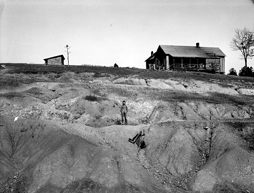
In the 1930s, the Dust Bowl and the legacy of massive post-Civil War cut-out-and-get-out logging and, particularly in the south, of what amounts to shifting cultivation brought a soil erosion crisis to the attention of the USA and the world. In the 1980s, a realization that problematic erosion persists despite great improvements in soil conservation and a heightened concerned with nonpoint source pollution from agriculture brought renewed attention to erosion, this time focused particularly on off-site impacts. On-site impacts of soil erosion are the environmental degradation and lost productivity due to soil loss, while off-site impacts are related to pollution and costs associated with where the soil ends up. Now, we are at it again, with another wave of attention to soil erosion.  

Eroded farmland in Alabama, 1930s (WPA photo by Arthur Rothstein).

How to Get Scientists to Ignore You

OK, so I tried to read Salvatore Engel-Di Mauro’s 2014 book, Ecology, Soils, and the Left: An Ecosocial Approach. As a geomorphologist who studies soil erosion (among other things), and as an environmentalist/conservationist interested in the human dimensions of erosion, it seemed a worthwhile piece of work (and probably is).  Years ago I was greatly influenced by Piers Blaikie’s 1985 The Political Economy of Soil Erosion—it even inspired me to develop a (widely ignored and little used, but I tried) method for modeling/estimating soil erosion in less developed countries where technocentric North American and European approaches were unlikely to be applicable.

Blaikie critiqued—often strongly—geomorphologists, soil scientists, and engineers. But he did so without insults and putdowns of scientists and science.

Not so Engel-Di Mauro. A few samples:

Biophysical scientists have proven historically to be largely subservient to the ruling regime of the day (and sometimes emphatically aligned with the ruling classes).

The Balance of Nature, and the Nature of Balance

If Mother Nature has plans, those plans are flexible. She keeps her options open, allows for more than one route to a given location, and we cannot assume that the same circumstances will always produce the same outcome. To digress for a moment: accepting this need not challenge religious or philosophical beliefs about a creator. Nothing in the bible, for instance, specifies exactly how the Judeo-Christian God goes about his/her business, or specifies any single pathways or mechanisms. As a protestant minister I knew well used to say: “Religion is concerned with the ‘why’ questions, and science addresses the ‘how.’”

Indeed. 35 years in the geoscience research business has shown me that that there is no single “right” or “natural” way for the world to be. Any human notions of singular, immanent norms or optima are tied to needs, goals, or perceptions, not scientific laws or relationships. And—again—there is nothing wrong with having such goals, desires, or expectations for nature, any more than there is anything wrong with a farm or a garden. The key is to realize that there is not much point in expecting Earth surface systems to evolve toward and maintain a single specific condition, any more than we would expect a garden to maintain itself without some guidance and intervention.

Talking Climate

In 1997, world leaders met in Kyoto, Japan to discuss how to confront, combat, and adapt to climate change. Eighteen increasingly warmer (on average) years later, a new set of climate talks start in Paris (France, not Kentucky) today (30 November), and continue for 12 days.

Some U.S. politicians have already courageously declared that the U.S. will do nothing, no matter how compelling the evidence, how severe the problems, or what the rest of the world thinks. As we get a new round of public commentary during and after the Paris talks, two recent studies—one journalistic and one academic—are worth considering.

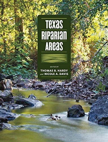
Texas Riparian Areas

Texas A&M University Press has recently published Texas Riparian Areas. According to TAMU Press's blurb: 

Riparian areas—transitional zones between the aquatic environments of streams, rivers and lakes and the terrestrial environments on and alongside their banks—are special places. They provide almost 200,000 miles of connections through which the waters of Texas flow. Keeping the water flowing, in as natural a way as possible, is key to the careful and wise management of the state’s water resources.


Texas Riparian Areas evolved from a report commissioned by the Texas Water Development Board as Texas faced the reality of over-allocated water resources and long-term if not permanent drought conditions. Its purpose was to summarize the characteristics of riparian areas and to develop a common vocabulary for discussing, studying, and managing them.

Connecting the Dot Factors

The standard conceptual model for pedology, soil geomorphology, and soil geography is often called the “clorpt” model, for the way it was portrayed in Hans Jenny’s famous 1941 book The Factors of Soil Formation:

S = f(cl, o, r, p, t) . . . .

This equation states that soil types or soil properties (S) are a function of climate (cl), biotic effects (o for organisms), topography (r for relief), parent material (p), and t for time, conceived as the age of the surface the soils are formed on, or the time period the soil has been developing under a given broad set of environmental controls. This factorial approach, considering soils as a function of the combined, interacting influences of environmental factors such as geology, climate, and biota, was originated by V.V. Dokuchaev in Russia in the 1880s, popularized in English by C.F. Marbut in the 1920s and 1930s, and developed by Jenny into the familiar clorpt form.

Quo Vadis Physical Geography?

The Canadian Association of Geographers recently held a special session on Changing Priorities in Physical Geography (I did not attend or participate; I was made aware of it by a Canadian colleague). The session description is given here. It got me to thinking about a piece I wrote more than a decade ago in response to a similar mandate, called Laws, Contingencies, and Irreversible Divergence in Physical Geography. I thought I would revisit what I published back in 2004 to see how it holds up. The paper focused on physical geography as science and scholarship, as opposed to the institutional politics of physical geography within geography as a whole, and relative to other disciplines. However, I did predict that physical geography—as geomorphology, climatology, biogeography, soil geography, and geospatial approaches to Earth & environmental sciences—would grow and thrive. However, I also expressed doubt that this work would continue to be called physical geography, and the extent to which it would be conducted under the institutional auspices of geography.

Subscribe to environment