Our Maps in Publications
Book Titles:
- Atlas of Kentucky
- Faces of Kentucky
- The Atlas of Central Eurasian Affairs
- The Great Valley Road Of Virginia
- Japan in the 21st Century: Environment, Economy, and Society
- On Jordan’s Banks: Emancipation and Its Aftermath in the Ohio River Valley
- Raccoon John Smith: Frontier Kentucky’s Most Famous Preacher
- Remaking the Chinese City: Modernity and National Identity, 1900-1950
- Replacing France: The Origins of American Intervention in Vietnam
- Southeast Asia: Diversity and Development
- Stalin’s Guerrillas: Soviet Partisans in World War II
- Work, Employment and Transition: Restructuring livelihoods in post-communism
- Worlds of E-Commerce: Economic, Geographical, and Social Dimensions
- Kentucky's Frontier Highway
FOCUS on Geography Magazine:
 |
Scotland sample 1 sample 2 sample 3 |
 |
 |
Greece sample 1 sample 2 |
Other Publications:
- Distribution of Black Population in Fayette County (2000 US Census-precinct level)
- Kentucky’s Frontier Trails: Warrior’s Path, Boone’s Trace, and Wilderness Road
- A Continuum in Teaching and Learning: Appalachian Mathematics and Science Partnership
- 2006 Map of Lexington and Fayette County, Kentucky: Rector-Hayden Realtor
- Map of Scott County, Georgetown, and downtown: Georgetown-Scott County Kentucky Museum
- Geography the Word around the World: Annals of the Association of American Geographers (supplement map)
Atlas of Kentucky
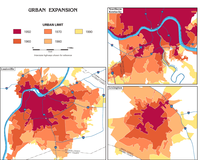
 The Atlas of Kentucky, put together by a team of geographers and cartographers from across the state and edited by Professor Richard Ulack (University of Kentucky), was published in 1997 by The University Press of Kentucky. After five years in the planning, research, and design stages, the Atlas is the most comprehensive source for information on Kentucky's land and life. Topics covered in over 600 maps and graphs include the natural environment, settlement patterns, population, mineral and timber resources, agriculture, manufacturing, transportation, tourism and recreation, and politics.
Atlas of Kentucky
By Richard Ulack, Karl Raitz, Gyula Pauer
Cartography by Donna and Dick Gilbreath
University Press of Kentucky, 1997.
Buy book at the The University Press of Kentucky
Samples