
Recently I had the pleasure of visiting the geography department at Texas A&M, and during my trip I was able to revisit some field sites along the Navasota River I had last been to in 2006. The lower Navasota is basically an anastamosing system--there is a single dominant channel, but multiple subchannels, some active at normal and low flows, at any given valley cross-section. One place is particular, Democrat Crossing, is a particularly confusing locus of recent and ongoing channel change.
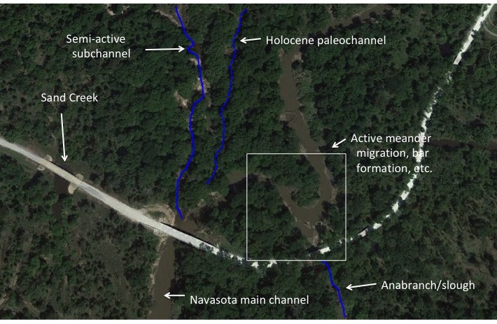
2017 Google EarthTMimage of Democrat Crossing. Sand Creek is actually a perennial or active Navasota River subchannel (semi-active means, in my lingo, that it usually carries flow, but may dry up in low-flow periods). Some of the subchannels have been highlighted with blue lines I added, as you can't really see them if you don't already know they are there.
This reminded me of the fact that in a number of rivers in many locations, I have noticed hotspots of lateral channel change. I began at one point (in 2013) to write up a paper/proposal to study this phenomenon, but it got lost in the shuffle. I present it below, in its quite incomplete and preliminary form, in the hopes that someone else may be inspired.
I visited the Navasota sites with Dr. Inci Guneralp and her PhD students Cesar Castillo and Billy Hales. I am confident they will have this particular hotspot figured out soon!
Introduction--Hotspots of lateral channel change
Hotspots of lateral channel change are specific reaches or subreaches where channel migration, cutoffs, avulsions, and other changes are more evident, frequent, and active than in upstream or downstream reaches. The purpose of this paper* is to examine the phenomenon of lateral change hotspots to identify the causes of this localized activity, and how these hotspots relate to the evolution and environmental controls of fluvial systems.
Examples of lateral migration hotspots are shown in Figure 1**. While these are rather obvious cases, as a starting point hotspots can be defined as areas of significantly greater sinuosity than up- or and downstream reaches, and/or with evidence of more frequent or recent cutoffs, oxbows, meander scars, multiple channels, paleochannels, or islands (collectively referred to as channel change indicators; CCI). As a rule of thumb, hotspots have sinuosities at least 30% greater, and/or a density of CCI at least double that of up- or downstream reaches.
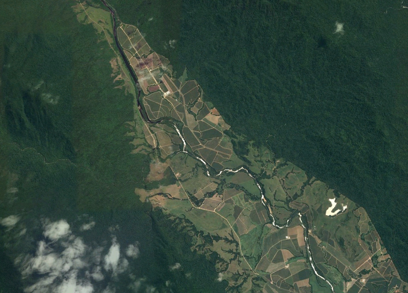
Figure 1. Tully River, NE Queensland, Australia. The Tully emerges from a confined valley, and immediately begins laterally migrating (note all the sand point and lateral bars, absent in the confined reach) and avulsing (note several abandoned channels and high-flow anabranches). (Google EarthTMimage).
Understanding hotspots of lateral channel change can shed light on channel change more generally. The hotspot concept is directly relevant to river planforms, sinuosity, cutoffs, avulsions, and lateral migration. These are also related to slope and vertical adjustments in several ways. First, increases in sinuosity are often a direct response to a local increase in slope, e.g., due to tectonics or base level change (Schumm, 2005). While sinuosity is defined as the ratio of length along the main channel or thalweg divided by valley distance, it is also the ratio of valley slope to channel slope. Further, crevasse, avulsion, and cutoff phenomena are associated with vertical changes such as channel aggradation (Jones and Schumm, 1999; Slingerland and Smith, 2004).
Localized increases in lateral activity are presumably linked to changes or variations in boundary conditions or controls along a river, or to local perturbations. Since these hotspots are relatively easy (at least as compared to other aspects of fluvial geomorphology) to identify from maps and imagery, they are potentially an important tool for indentifying critical hinge points, boundaries, and localized disturbances. Additionally, lateral channel change hotspots are associated with higher levels of geodiversity and hydrodiversity, and thus are likely candidates to be local hotpots of habitat, soil, and biodiversity. Finally, lateral change hotspots may often be associated with erosion and flood hazards, land loss, and a variety of river and riparian management and engineering issues.
Theory and background
Lateral channel change requires bank erosion on at least one side of a channel, or a levee or banktop breach (crevasse) that results in a new channel. Thus for such changes to occur the force of flow, as directly measured by shear stress, or indicated by stream power, must be greater than the resistance of bank or floodplain materials. Thus, hotspots may be due to local factors that increase the force/resistance ratio.
Thus, local increases in flow (discharge and/or depth) and/or slope can increase the force/resistance ratio. This can occur due to hydrologic inputs, geological or tectonically imposed channel slopes, or flow constrictions, which may increase depths and velocities and create steeper hydraulic slopes.
Force/resistance may also be increased due to lower resistance, often associated with low-cohesion but relatively small grain size materials (i.e., sand or gravel), or reductions in vegetation cover.
Stream power and shear stress are also related to sediment transport capacity and competence, and channel change can also be associated with changes in the relationship between sediment supply and transport capacity (SS/TC). This may work in several ways:
•A sharp decrease in SS/TC (e.g., below a dam) may result in flow with excess force. While this most often results in vertical scour, where the latter is limited by resistant bed materials or local base levels, increased lateral migration may result.
•A significant increase in SS/TC may trigger a change from a single-channel to an anabranching planform (braided, wandering, or anastamosing).
•Channel aggradation associated with SS/TC > 1 is a setup condition for cutoffs and avulsions.
While this could be triggered by flow losses or diversions, the most likely causes are reduced slope (thus lowering TC), or major inputs of sediment, e.g., from slope failures or tributaries. Flow obstructions such as large woody debris, or damming by ice, landslides, migrating aeolian dunes, etc., can also lower hydraulic slopes and reduce flows.
Finally, lateral migration may be a simple function of lateral accommodation space—that is, room to move. Valley confinement (see Brierley and Fryirs, 2005) and valley-to-channel width ratios are important in this regard. Lateral migration hotspots could be controlled by local variations in valley width.
(there was some additional musing & arm-waving about methods, but that's pretty much it).
Navasota River at Democrat Crossing. There are no obvious external controls here (e.g., valley width/confinement; evidence of tectonics or listric faulting, large sediment inputs, etc.).
*As mentioned, no paper ever actually materialized.
**There would have been more than the one example shown; they are not that hard to find.
--------------------------
Posted 2 May 2018