
One of the classic principles/relationships in biogeography is called the species-area curve, relating the number of different species found (usually of some particular taxonomic group; e.g., birds or plants) to the area sampled. These curves are usually well fit by an exponential relationship:
S = c A b
where S is the number of species, A is area, c is a constant representing the number of species in the smallest area sampled, and b represents the rate of increase of species with area. While b could be greater than 1 if major biogeographical boundaries are transgressed (so that whole new sets of species are encountered), otherwise b < 1, and usually much less; 0.25 is a fairly common value.
Juanjo Ibanez and I (in separate studies) found that similar trends apply to soil diversity, with S in this case indicating number of different soil types (e.g., soil series). In his very broad scale analyses, Juanjo also found b » 0.25, while in my landscape-scale studies b was in the range of 0.6. Syntheses of this work are found in the book Pedodiversity (CRC Press, 2013) edited by Ibanez and James Bockheim.
The flattening out of the curves (i.e., b < 1) reflects the fact that as more area is sampled, you do find new soils or species, but increasingly you encounter types that have already been enumerated. Does the same general pattern hold for diversity of geomorphology along rivers?
I have done geomorphic zonation studies for four different rivers in Texas in support of the Texas Instream Flow Program, along lengths of river ranging from about 210 to 700 km (Sabine, Trinity, Brazos, and Guadalupe Rivers). From this, a relationship between river or valley length sampled and geomorphic diversity can be determined.
The geomorphic zones were identified using the River Styles approach pioneered by Kirstie Fryirs and Gary Brierley (see their book Geomorphology and River Management. Applications of the River Styles Framework, Oxford UP, 2005). Geomorphic zones or river styles were identified based on similarities of geological setting, hydrologic regime, valley confinement, dominant substrate types, morphometric properties such as slope and sinuosity, planform, and other properties relevant to specific rivers such as presence or absence of sandy point bars, avulsed reaches, and dam effects.
Using these maps, for each river I sampled every 10 km in the upstream-downstream direction, counting the total number of geomorphic zones or river styles encountered. Rather than power functions of the type found in soil richness and species-area curves, the relationships are all linear—the more channel you sample, the more styles (geomorphic diversity) you encounter, with the geomorphic diversity increasing in direct proportion to length.
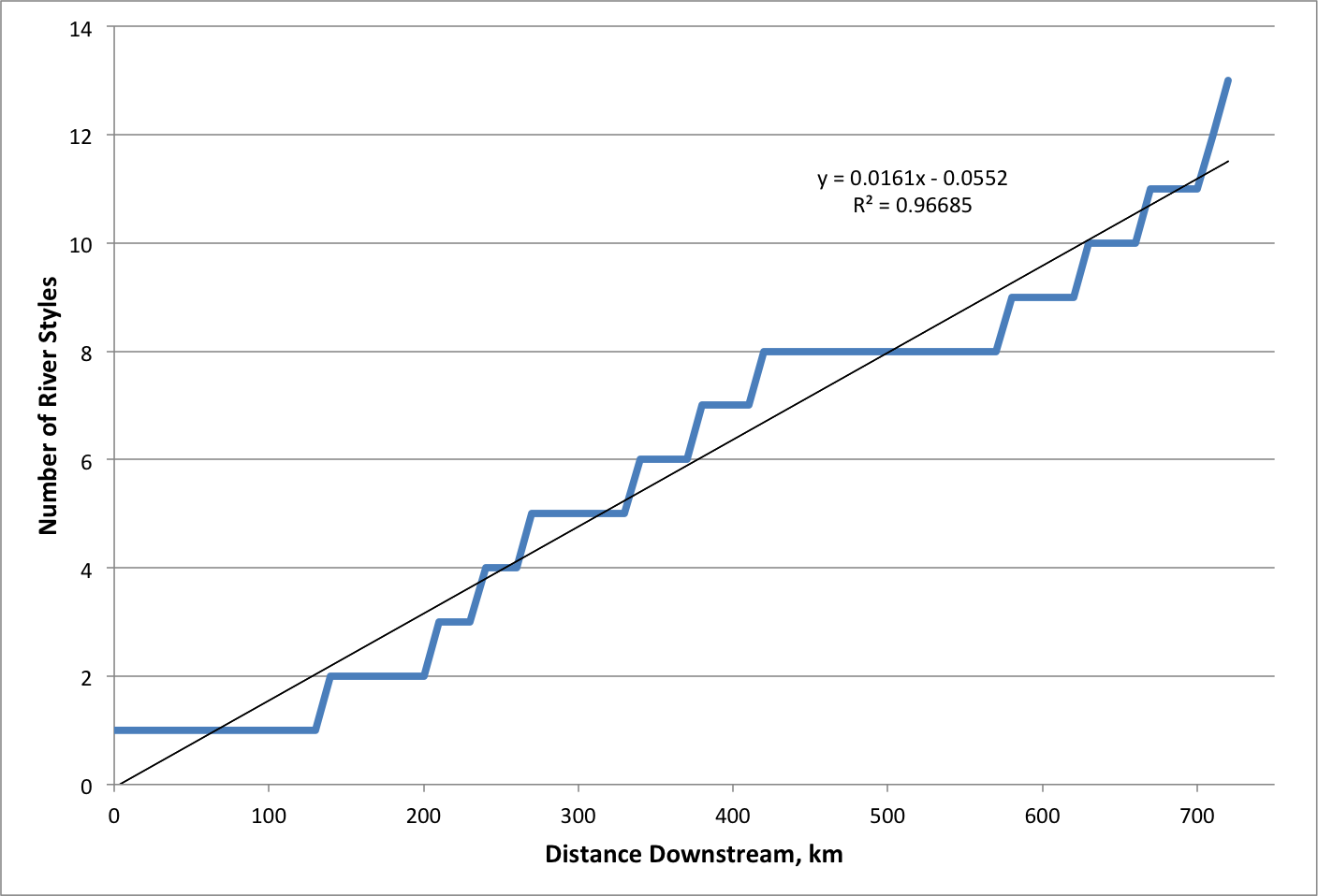
Results for Guadalupe River
In some cases—particularly the Guadalupe River—the studied section passes through several different ecoregions and physiographic provinces. However, in the Trinity example (basically the river from Dallas downstream) this external variability is much more limited, and the Sabine (downstream from Toledo Bend) is entirely within the coastal plain. In all four cases, the study areas extended to the mouth of the river at the coast. Thus, in the lower reaches it was inevitable that new river styles associated with deltaic environments and coastal backwater effects would be found—thus the curves could not flatten out at the very end. But even if this is discounted—for instance, if you chopped off the lower end--the relationships would still be linear. The relationships are given below, where RS = number of river styles and L = river length or distance downstream.
Sabine: RS = 0.0272 L + 0.6668 R2 = 0.96
Trinity: RS = 0.0292 L + 2.5175 R2 = 0.98
Brazos: RS = 0.0559 L – 3.0732 R2 = 0.98
Guadalupe: RS = 0.0161 L – 0.0552 R2 = 0.97
I need to think about this some more, but right now two potential (and not mutually exclusive) explanations come to mind.
First is the inherent variety of rivers and landforms. As I have argued before in many contexts, any geomorphic system represents a specific combination of environmental controls and history unlikely to be duplicated elsewhere. Thus, even within a single river system, as you move down (or up) stream you inevitably encounter new, unique combinations and thus new geomorphic zones. The nature of rivers is such that, even where the external environmental controls are constant, along the channel discharge is systematically changing, new tributaries are encountered, and local disturbances occur.
Second is the way geomorphic zones or river styles are identified. It is not a classification system in the sense of pre-existing categories (such as biological species or soil taxa) that river segments are placed into (there are such classification systems; it would be interesting to do a similar analysis using a pigeon-hole type classification). Given that one is not obliged to find a best-fit category, this reduces the likelihood that duplicate categories will arise.
It would be interesting do a similar analysis for more detailed levels of geomorphic classification, such as geomorphic and hydraulic units. In the lower Sabine, geomorphic units (GU) and hydraulic units (HU) have been identified, and linked to the geomorphic zones, but not mapped in such a way as to enable a length vs. diversity analysis. The six river styles of the lower Sabine contain 35 GUs and 82 HUs within the channel. Some GUs occur throughout; others are restricted to particular river styles. Some HUs are widespread, but none occur in every river style. Thus, while I cannot show you a quantitative analysis, I can say with confidence that, at least in the Sabine, a similar plot of GUs and HUs would show a steady, probably linear, increase with length or distance.
Also, what about a species-length curve along a river, examining the rate of increase in the number of fish, diatom, or aquatic macrophyte species along the channel? Since geomorphic categories are closely related to habitats, would the trends be similar? Or are species habitat preferences more general (e.g., a particular critter or microbe may need or prefer a muddy pool, but beyond that the other geomorphic aspects of the setting may not matter)?
Lots to be done here!
The technical reports containing the geomorphic zonations can be obtained here. The relevant titles are:
Hydraulic Units of the Lower Sabine River (2011).
Flow Modifications and Geomorphic Thresholds in the Lower Brazos River (2013)
Geomorphic Processes, Controls, and Transition Zones in the Middle and Lower Trinity River (2008)
Field Data Collection in Support of Geomorphic Classification of the Lower Brazos and Navasota Rivers (2007)
Geomorphic Processes, Controls, and Transition Zones in the Guadalupe River (2011)