
In the lower reaches of some coastal plain rivers there is a transition from mineral to organic alluvial soils, which appears to mark the leading edge of effects of sea-level rise. This post is part of project to address the question of how a river, swamp, or floodplain undergoes a transition--apparently relatively suddenly in some cases, judging from stratigraphy--from a muddy or sandy, mineral-dominated state to one that is overwhelmingly composed of organic matter? For background, see this previous post.
The formation of peats and mucks depends on a rate of organic matter production by vegetation that exceeds the rate of decay and decomposition (or combustion). The classic setting is a peat bog, where wet, anaerobic conditions slow decay in conditions where organic matter as well as water tends to accumulate. These are most common in higher latitudes, where cold as well as water saturation retards decay, but peat bogs called pocosinsoccur in the Atlantic coastal plain from southern Virginia to northern Florida, and are particularly common in North Carolina.
Pocosin peat soils on a hemp farm, Dare County, N.C. (photo: Blacklands Botanicals, LLC).
Both peat and muck soils are composed primarily of partially decomposed organic matter. Peats are generally coarser, more fibrous, materials; mucks tend to be fine-grained, more colloidal, and more highly decomposed. Peat and muck layers are described as O-horizons in soil descriptions, and peat and muck soils are classified as Histosols in the World Reference Base for Soil Resources and U.S. Soil Taxonomy. You will also see descriptions of transitional layers (e.g., mucky peat; mucky clay loam).
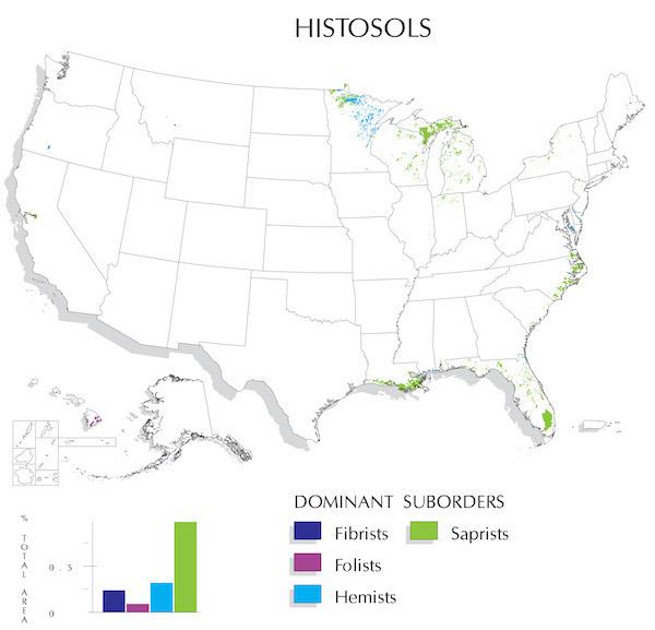
U.S. Department of Agriculture map of Histosol distribution in the U.S.A.
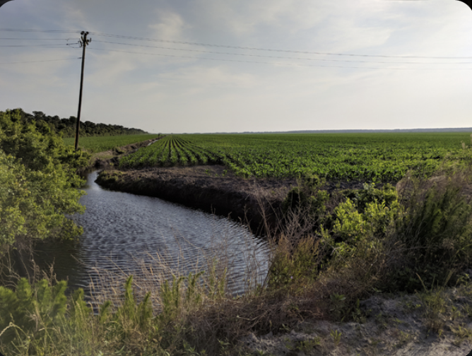
Unlike peat bogs and the isolated wetlands where peats and mucks usually form, alluvial swamps often have water flowing through, in, and out. This is demonstrably true in the lower Neuse River, N.C. (Phillips, 2022), and in other rivers of the Carolinas I have observed, including the Tar-Pamlico, Cape Fear, Waccamaw, and Pee Dee. Thus, it is not obvious—at least not to me—why the conditions for peat/muck accumulation are so readily achieved in some alluvial settings, where (at least intuitively) some flushing of particulate organic matter and even wood should occur.
One possibility is that the organic-soil alluvial swamps are sinks for transported organic matter—that is, the input of fluvially-transported material exceeds the output. This could conceivably occur due to backwater effects, which is at least broadly consistent with their location in fluvial-estuarine transition zones in many cases.
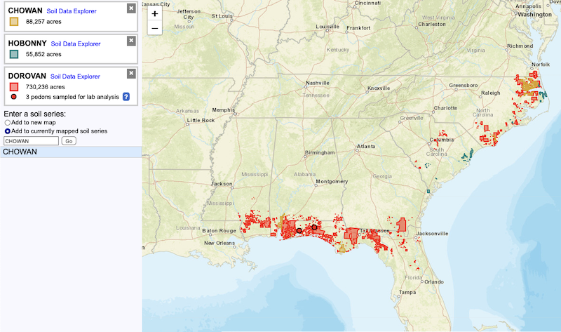
The three recognized soil series of interest in this project are the Dorovan, Hobonny, and Chowan series. Below is a screenshot from the Series Extent Explorer showing where these soils have been mapped in the U.S.
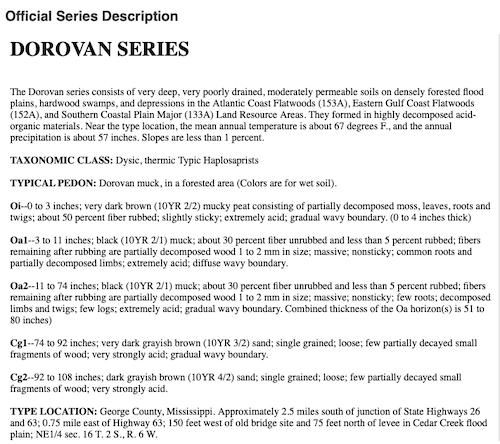
The official description of the Dorovan series from its type location in Mississippi is shown below. The Hobonny series, named for the Hobonny Plantation, a former rice plantation in South Carolina, is similar, but less acid—a Euic (vs. Dysic for the Dorovan) thermic Typic Haplosaprist). The Chowan series, first recognized and named in Chowan County, N.C., is basically a histosol similar to the Dorovan or Hobonny that has been buried by recent mineral sediment deposits. The Chowan, a Fine-silty, mixed, active, nonacid, thermic Thapto-Histic Fluvaquent (gotta love those Soil Taxonomy monikers), typically has 40 to 100 cm of loamy mineral sediment with minimal pedogenic development overlying sapric muck or peat. Because the surface layers are nonacid (atypical for the region), their presence is attributed to runoff and erosion from nearby limed uplands, an interpretation I agree with.
In ongoing and future work I’ll be looking at the geography of these soils, including where they are not found in the lowermost fluvial reaches or fluvial-estuarine transition zones of coastal plain rivers. I’ll also be exploring how (or if) their distribution corresponds with other indicators or controls of sea-level effects on rivers (see Phillips, 2022).
----------------------------------------------------------------------
Phillips, J.D. 2022. Geomorphology of the fluvial-estuarine transition zone, Neuse River, North Carolina. Earth Surface Processes and Landforms 47: 2044-2061 (attached).