
As rivers flowing across the coastal plains of the Carolinas approach the coast and their estuaries they widen, split into multiple channels, and flows can slow or reverse as astronomical tides, wind tides, and storm surges downstream have their effects. And on their floodplain swamps, the sandy and muddy soils and sediments give way to organic mucks or peats.
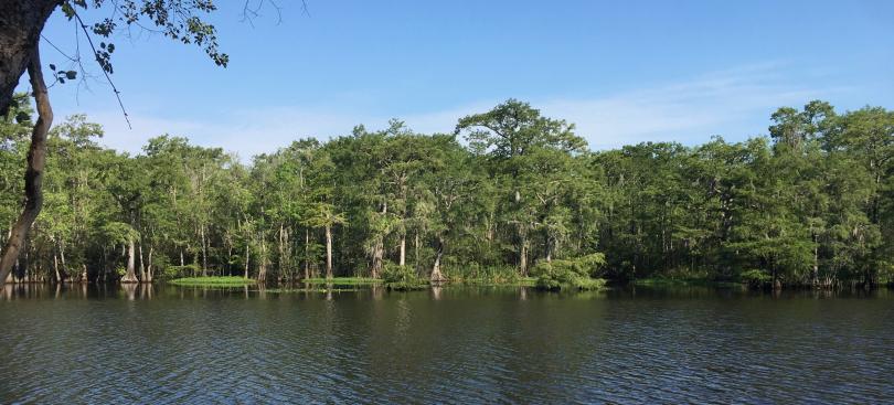
Area of organic muck soils, Thorofare Island, Waccamaw River, S.C.
For instance, on many North Carolina rivers these soils are mapped as the Dorovan series (for you fellow soil nerds, Dorovan is a Dysic, thermic Typic Haplosaprist; the official series description is here). These are typically 1.3 m or more of muck, peat, or mucky peat overlying mineral sediments.
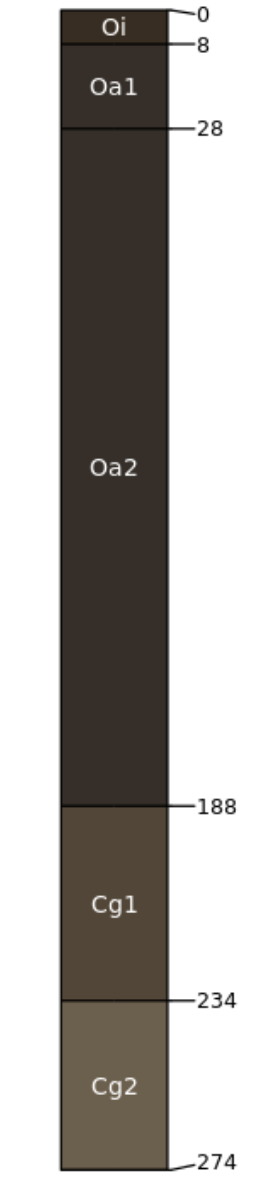
Example Dorovan soil profile, based in the series type location in Mississippi.
Back in the 1980s, the venerable soil geomorphologist Raymond Daniels recognized the Dorovan muck as representing the leading edge of the effects of Holocene sea-level rise on floodplain geomorphology and pedology along N.C.’s coastal plain rivers. In my early 1990s studies of those rivers, after comparing the geography of the Dorovan series with other controls and indicators of the relative effects of upstream and downstream controls on sediment transport and river morphology, I agreed. Still do.
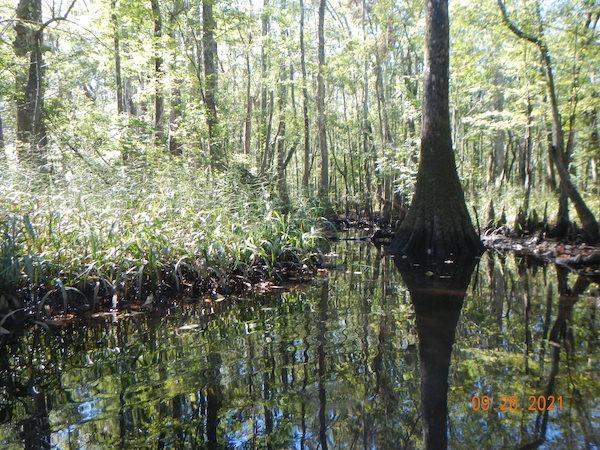
Typical area of Dorovan muck, backwaters of lower Neuse River, N,C.
I’ve returned to the Dorovan muck and similar soils recently as I’ve been working on effects of climate, sea-level rise, and direct human modifications on lower coastal plain rivers, and doing a lot of kayaking in the mucky parts of some of those rivers. The key question is how does a river, swamp, or floodplain transition--apparently relatively suddenly in some cases, judging from stratigraphy--from a muddy or sandy, mineral-dominated state to one that is overwhelmingly composed of organic matter?
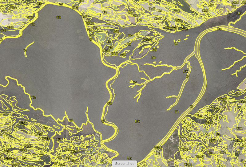
Soil map showing transition from mineral Chastain soil series (symbol Ch) to the Dorovan mucky peat (symbols Dk, Do) along the Roanoke River near Williamston, N.C. From SoilWeb (https://casoilresource.lawr.ucdavis.edu/gmap/)
You could see this as a local or regional puzzle to solve, and you would not be wrong. But solving (or at least addressing it) could shed some light on wetland evolution and development, the little-understood dynamics of fluvial-to-estuarine transition zones, and sea-level impacts on rivers. The areas characterized by Dorovan and similar soils are part of landforms and ecosystems that have very high values for wildlife habitat, flood and storm protection, water quality, and recreation. They are also highly vulnerable not only to sea-level rise, but also rampant land development, in some cases at a nearly crazed pace (see Horry County, South Carolina for instance). While the wetlands themselves may be protected from the excavators and bulldozers, the adjacent wetlands are subject to their adverse impacts on water quality, habitat and hydrological connectivity, and space for responses to sea-level change.
As indicated above, the geography of these soils seems to be a good indicator of the leading edge of relative sea-level impacts. As I will discuss in a future post, multiple possible factors may be involved in the transition, so the story of the alluvial mucks may shed light on the common phenomenon of multiple causality in Earth surface systems. The mineral-to-muck (or peat) shift is also an example of a system transition that may represent, and shed light on, the broader study of regime shifts and tipping points.
All of these will be explored as this project proceeds.