
Fluvial (river or stream) terraces are former active floodplain or channel surfaces that become isolated from regular flow or inundation by downcutting (incision) of the channel. Alluvial terraces start as predominantly depositional floodplains, but as the river incises, they eventually become isolated from flooding and deposition in all but the largest, rarest floods. Strath terraces are erosional surfaces associated with former channel positions; again, separated from river flows by downcutting of the channel.
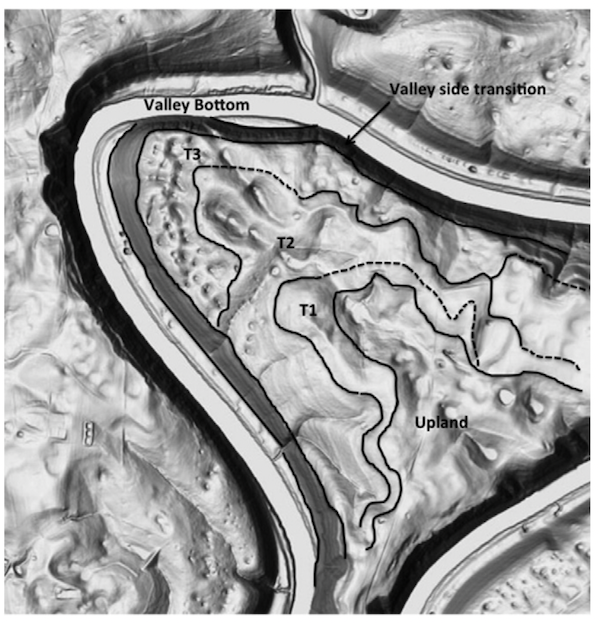
Polly’s Bend, Kentucky. The T1, T2, T3 areas are strath terraces in oldest-youngest order. Base map is shaded relief based on 1.5 m resolution digital elevation model. Area shown is about 2.7 km (north-south) by 2.5 km (east-west). Coordinates at center are 37.8022° N, 84.6472° W (Fig. 2 from Phillips, 2018).
The strath terraces I am most familiar with occur on slip-off slopes on the inside of incised meander bends of the Kentucky River. As the river has incised over the past ~1.5 Ma, the meander bends have also extended by erosion on the outer bend, as meanders do. This leaves abandoned erosional surfaces on the inside of the bend, as shown below. This is described in Phillips (2018; attached).
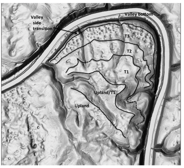
Bowman’s Bend, Kentucky. The T1, T2, T3 areas are strath terraces in oldest-youngest order. Base map is shaded relief based on 1.5 m resolution digital elevation model. Area shown is about 3.2 km (north-south) by 3.5 km (east-west). Coordinates at center are 37.8161° N, 84.6927° W (Fig. 2 from Phillips, 2018).
Recently I had the chance to observe formation of some strath terraces that occurred over a matter of <24 hours in a small, flashy stream flowing across a sandy estuarine beach.
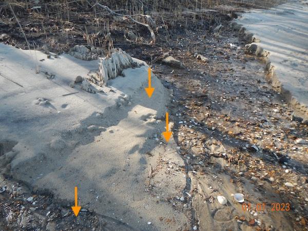
Freshly formed strath terraces near the outlet of Tadpole Swamp Creek. Arrows show two terraces and (at bottom) a channel on the verge of being abandoned to form a third.
Tadpole Swamp Creek is a small tributary of the Neuse River estuary in Craven County, North Carolina. The creek terminates in a deepwater hardwood ravine swamp near the estuary. Before 2018 there was an incised channel connecting it to the river. In September 2018 deposition from Hurricane Florence plugged the channel. Outflow from Tadpole began spilling out from several locations along the swamp edge (the swamp is perched on a Pleistocene swamp paleosol roughly a meter above mean river and sea level). New channels are starting to incise, and during normal conditions all flow except for a few small seepage points is via a single outlet. At higher flows, however, multiple channels at the outflow are activated or formed, as the still-forming main channel cannot handle the flow.
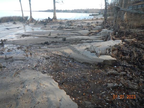
Outflow(s) of Tadpole Swamp Creek on 1 January 2023.
Heavy rains came in late December 2022. The swamp flowed, or overflowed. On the morning of New Year’s Eve, I counted 11 channels that had recently been flowing across the beach, 8 of which still carried at least a trickle.
As the substrate is mainly loose sand, channel erosion is rapid. However, the stage of the outflow also declined rapidly as the channels incised, and as flow diminished after the rains ended. This left behind multiple channels and strath terraces, which will be preserved until the next large outflow rearranges things, or the next northeaster storm pushes the estuary waters to the edge of the swamp and resets the stage for the outflow fluvial features (rearrangement of the beach and outflow by waves and/or outflows occurs dozens of times a year).
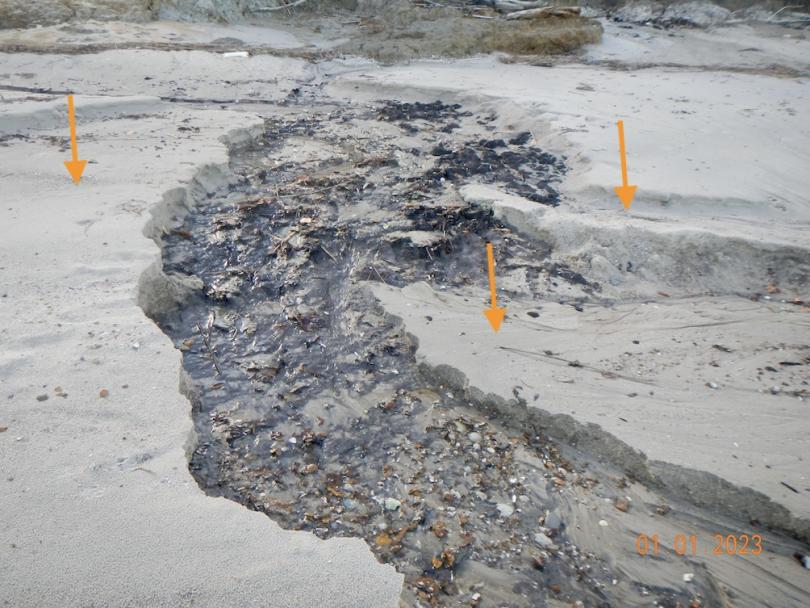
Arrows indicate strath terraces on one of the outflow channels.
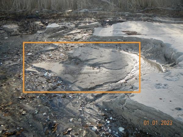
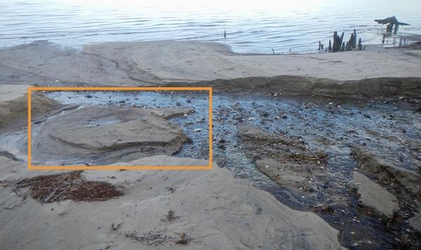
There existed several cases of formation of strath terrace islands, as shown in the photographs below (highlighted by boxes). These formed as flows bifurcated during incision. This is a common phenomenon in braided channels, but isolated alluvial terrace remnants (islands, as opposed to terraces along the valley side) also occur.
------------------------------------------------------------------
Phillips, J.D. 2018. Historical contingency in fluviokarst landscape evolution. Geomorphology 303, 41-52 (attached).