
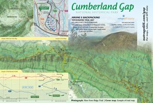
Map packaging artwork We've been hard at work finishing our trail map for the Cumberland Gap National Historical Park and surrounding area. This project is an update of our first Gap trail map. We're hoping to have the maps in stock by Memorial Day, 2017. Our new map is on a larger sheet size (39" x 13.35" divided into two sheets for convenient use) and at a scale of one-inch to a half-mile. Please explore the drafts via links below and let us know if you have any suggestions.
Artwork drafts
Map side: https://outragegis.com/gap/map Elevation profile side: https://outragegis.com/gap/legend Map packaging artwork: https://outragegis.com/gap/cover
https://www.outragegis.com/trails/2017/04/05/drafts-of-cumberland-gap-map/